


747-400 step climb procedure

Thread Starter
Join Date: Jul 2007
Location: Paris
Age: 43
Posts: 9
Likes: 0
Received 0 Likes
on
0 Posts
747-400 step climb procedure
Hi everyone,
Did a quick search but could not find what I am looking for.
Difference btw OPT and MAX FMC computed altitudes can be as much as 4000 ft. What is the most efficient method to step cruise in the 744? Flying close to optimum (within 1000 ft)? Or right in the middle of the OPT and MAX FMC computed altitudes? Or even close to MAX?
Thank you in advance for any information!

Join Date: Mar 2011
Location: Earth
Posts: 172
Likes: 0
Received 0 Likes
on
0 Posts
If you have the original sperry or non-NG Honeywell software FMC (and it sounds like you do):,
You should probably use the altitudes that your flight planning software/paperwork recommends. Step size should 0 if you're going to use your flight plan altitudes, then program step climbs on the legs page where you intend to climb using the 330S, 350S, 370S format, etc etc. You'd get these altitudes and the points at which they are to occur from the flight plan provided by your dispatcher/flight follower/company/whomever.
If you have the honeywell NG FMC (the one that comes with the 747-8 and can be retrofitted to the -400), fly recommended altitude (assuming you have provided the FMC with winds for your route either through data uplink or manual inputs from the forecast). Recommended considers winds and temps 250-500 NM ahead of the aircraft and recommended altitude uses altitude "wind trade" math to best comply with the targets (non-fuel costs/fuel cost) of your selected cost index. With the NG FMC that has recommended altitudes, step size should either be RVSM (or 1000 ft if you think you have a chance at getting altitudes that are incorrect for direction of flight).
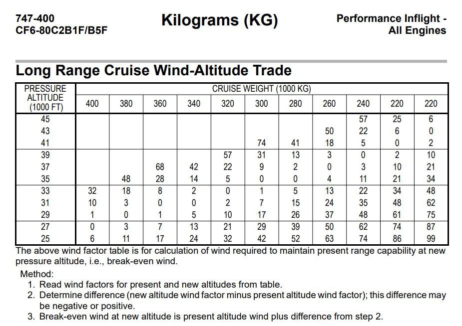
If you lack both flight plans with altitudes and the Honeywell NG FMC, I guess you'd just fly optimum with RVSM step size, or eyeball the winds aloft forecast and use your best judgement, but I find it hard to believe that would be the case. You could start with the optimum altitude the use a chart like this, if you have a winds forecast:.
Or you could experiment in the FMC with different, altitude and wind values and compare the time/fuel remaining to determine if straying from optimum will be worthwhile based on winds.
You should probably use the altitudes that your flight planning software/paperwork recommends. Step size should 0 if you're going to use your flight plan altitudes, then program step climbs on the legs page where you intend to climb using the 330S, 350S, 370S format, etc etc. You'd get these altitudes and the points at which they are to occur from the flight plan provided by your dispatcher/flight follower/company/whomever.
If you have the honeywell NG FMC (the one that comes with the 747-8 and can be retrofitted to the -400), fly recommended altitude (assuming you have provided the FMC with winds for your route either through data uplink or manual inputs from the forecast). Recommended considers winds and temps 250-500 NM ahead of the aircraft and recommended altitude uses altitude "wind trade" math to best comply with the targets (non-fuel costs/fuel cost) of your selected cost index. With the NG FMC that has recommended altitudes, step size should either be RVSM (or 1000 ft if you think you have a chance at getting altitudes that are incorrect for direction of flight).
If you lack both flight plans with altitudes and the Honeywell NG FMC, I guess you'd just fly optimum with RVSM step size, or eyeball the winds aloft forecast and use your best judgement, but I find it hard to believe that would be the case. You could start with the optimum altitude the use a chart like this, if you have a winds forecast:.
Or you could experiment in the FMC with different, altitude and wind values and compare the time/fuel remaining to determine if straying from optimum will be worthwhile based on winds.
Last edited by RandomPerson8008; 3rd Aug 2021 at 08:03.
